Scientific Investigations Report 2006-5030
U.S. GEOLOGICAL SURVEY
Scientific Investigations Report 2006-5030
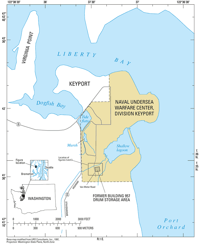
Shallow ground water is contaminated with chloroethenes beneath the former Building 957 drum storage area at the Naval Undersea Warfare Center, Division (NUWCD) Keyport, Washington (figs. 1 and 2). Solvents, fuel, and oil were stored on the formerly unpaved area, and an estimated 4,000‑8,000 gal of these chemicals were discharged to the ground (URS Consultants, Inc., 1993). Administratively, the site is part of Area 2 of Operable Unit 2 at NUWCD Keyport, and is being remediated under authority of the Comprehensive Environmental Response, Compensation, and Liability Act.
Primary contaminants of concern in ground water at Area 2 are the chloroethene compounds—trichloroethene (TCE) and vinyl chloride (VC), although cis‑1,2‑dichloroethene (cis-DCE) and BTEX (benzene, toluene, ethylbenzene, and xylene) also have been detected (URS Consultants, Inc., 1993). Contaminant concentrations at the site always have been relatively low, so human health risks, ecological risks, and the potential for offsite migration were determined to be low (URS Consultants, Inc., 1993). Therefore, remedies selected for Area 2 were ground-water monitoring to document the expected decrease of chloroethene concentrations, and institutional controls to exclude residential use and prevent construction of water-supply wells (URS Consultants, Inc., 1994).
Chloroethene concentrations in ground water at former Building 957 drum storage area have been monitored regularly by the U.S. Navy since 1995 to document the expected decreases in concentration due to natural attenuation processes. Data indicate that concentrations generally have decreased (CH2M HILL Constructors, Inc., 2003). To better understand the measured decreases in concentrations, the U.S. Geological Survey (USGS) collected water samples from wells at former Building 957 drum storage area, analyzed the samples for geochemical and chloroethene concentrations, and evaluated the data for evidence of chloroethene biodegradation.
This report describes the results of a study to evaluate evidence for biodegradation of chloroethenes in ground water at former Building 957 drum storage area, Area 2, Naval Undersea Warfare Center, Division Keyport, Washington. Water level, geochemical, and chloroethene data collected by the USGS from eight wells during 2003 are presented and evaluated along with data collected by the U.S. Navy from 1991 to 2004.
NUWCD Keyport is mostly on a small peninsula in Kitsap County, Wash., in an extension of Puget Sound called Liberty Bay (fig. 1). The base occupies the eastern part of the peninsula, which is connected to the mainland by a narrow strip of land that was mostly tidal wetland before it was filled in by the Navy by the 1940s. The mainland to the west and southwest of Keyport peninsula rises steeply to rolling uplands at an altitude of 200–400 ft.
Keyport has a temperate marine climate characterized by warm, dry summers and cool, wet winters (Washington State University, 1968). Mean annual temperature is about 51°F; January is the coolest month and July is the warmest. Mean annual precipitation is about 31 in., 77 percent of which falls from October through March. Snowfall is infrequent and rainfall generally is not intense.
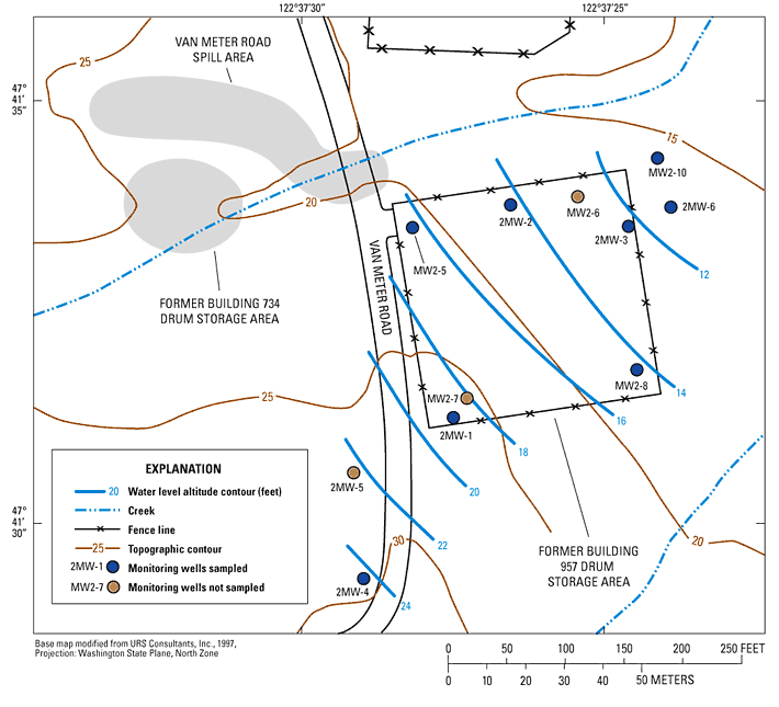
Area 2 is in the southwest corner of NUWCD Keyport (fig. 1), and includes three distinct contaminant sites: Van Meter Road spill area, former Building 734 drum storage area, and former Building 957 drum storage area (fig. 2). The one-third acre former Building 957 drum storage area is the focus of this report. The site is about 500 ft southwest of a shallow lagoon that is an extension of Liberty Bay, and is about 40 ft south of an unnamed creek that drains into the lagoon (fig. 1). The altitude of the site is 20 to 25 ft, and the land rises steeply to the south and west of the site. The area immediately surrounding the site is primarily forested.
NUWCD Keyport is in the Puget Sound Lowland, a topographic and structural depression between the Cascade Range to the east and the Olympic Mountains to the west. Keyport peninsula and surrounding areas are composed primarily of unconsolidated Pleistocene glacial and interglacial deposits overlying Tertiary and older bedrock (Blunt and others, 1987). A veneer of more recent alluvium, including stream, beach, landslide, and marsh deposits, covers the youngest glacial deposits in some areas. Unconsolidated deposits are more than 1,500 ft thick beneath the Keyport peninsula (Jones, 1999).
Ground water beneath Area 2 is in a series of aquifers composed of permeable sand, gravel, or fill materials separated by finer grained silt or clay layers. Contamination at Area 2 is known to occur only in the approximately 30-ft thick unconfined aquifer beneath the site, and only that aquifer is described in this report; see Kahle (1998) and Jones (1999) for information about deeper sediments.
The unconfined aquifer consists of five defined water-bearing units, many present over limited areas, overlying a regionally extensive and thick confining unit consisting of clay and silt (URS Consultants, Inc., 1993). The uppermost water-bearing unit consists of about 10 ft of artificial fill. Most fill is unsaturated and has variable lithology and permeability. A discontinuous unit consisting of as much as a few feet of organic-rich silt, clay, and sand lies beneath the fill. These marsh and tide flats deposits are mostly fine-grained, but generally are not compacted and are somewhat permeable. A discontinuous unit consisting of as much as 15 ft of sand and sandy gravel lies beneath the marsh and tide flats deposits. These advance glacial outwash deposits are highly permeable. A continuous unit consisting of as much as 25 ft of silt, fine sand, and clay lies beneath the outwash deposits. These non-glacial deposits have relatively low permeability, but not low enough to be considered a confining layer by previous site investigators.The lowest part of the uppermost aquifer is a continuous unit consisting of 2-7 ft of clean to silty sand with local gravel. These non-glacial deposits have moderate permeability.
Small perennial creeks north and south of the former Building 957 drum storage area flow from the southwest to the northeast towards the shallow lagoon. Ground water flows from the southwest towards the northeast beneath the site, and likely discharges to the northern creek at some distance downgradient from storage area (fig. 2). Water levels at the site are not tidally influenced. The horizontal hydraulic gradient beneath the site is about 0.05 ft/ft (URS Consultants, Inc., 1993), and the estimated hydraulic conductivities for the uppermost aquifer range from 0.14 to 11 ft/d, with a geometric mean of 1.2 ft/d (URS Consultants, Inc., 1993). The slug tests used to estimate hydraulic conductivities did not indicate any depth specific or consistent spatial trends. Assuming an effective porosity of 0.25 for the aquifer, the estimated linear ground-water flow velocity ranges from 0.03 to 2.2 ft/d with an assumed geometric mean of 0.24 ft/d.
The author thanks Douglas Thelin of the Naval Facilities Engineering Command, Engineering Field Activity, Northwest for his guidance and for securing funding for the continued monitoring. Gene Ellis of NUWCD Keyport provided logistic support for field activities. Bernie Wong of CH2M HILL Constructors, Inc., in Bellevue, Wash. provided additional chloroethene data.
For more information about USGS activities in Washington, visit the USGS Washington Water Science Center home page .

![]() U.S. Department of the Interior |
U.S. Geological Survey
U.S. Department of the Interior |
U.S. Geological Survey
Persistent URL: https://pubs.water.usgs.gov/sir20065030
Page Contact Information: Publications Team
Page Last Modified: Thursday, 01-Dec-2016 18:54:45 EST
