![]()
Changes from the original module are written in bold text
If the ground-water outflow is to go to a stream node and not to the basin outflow (standard PRMS), then the musroute_prms.f module is required. Each HRU requires its own ground-water reservoir. Basin characterization into HRUs should be done using a grid/lattice or a 2-flow-plane initial characterization so water from the ground-water reservoirs goes to right or left banks of stream. Standard PRMS does not require this. However, if the basin characterization was completed in this manner for the standard PRMS streamflow accounting (accumulation at basin outflow), this would result in HRUs along the stream that would move ground water to those HRU reservoirs and ultimately to the basin outlet, which is at lowest elevation. The HRU number for the gw_res_2_res_id parameter that represents the downslope ground-water reservoir must correspond to an HRU with a lower mean HRU elevation than the mean HRU elevation representing the upslope ground-water reservoir.
Sums inflow to ground-water reservoirs and computes outflow to streamflow and to a ground-water sink if specified. Includes a new parameter that sets a minimum ground-water storage for each reservoir that is maintained at all times (see description below). If this parameter is set equal to zero, then the module is the same as the original PRMS module. Allows ground water in the reservoirs identified for each HRU to move laterally to other HRUs and ultimately to the stream for the HRUs that abut streams.
Ground water is moved from an upslope to a downslope ground-water reservoir based on their elevation difference, storage in upstream reservoir and average of the two input ground-water routing coefficients for the two (upslope-downslope) reservoirs. This formulation assumes that the ground-water surface resembles the topography. For reservoirs that do not pass water to (1) another reservoir but give water to a stream node (using musroute_prms.f) or (2) streamflow at basin outlet (standard PRMS), then the reservoir outflow is calculated using the original PRMS equation.
Ground-water routing coefficient to obtain ground-water flow contribution to streamflow or to downslope ground-water reservoir associated with downslope HRU.
Ground-water sink coefficient to compute the seepage from each reservoir to a ground-water sink.
Storage in each ground-water reservoir at beginning of run, in inches.
A factor representing the inverse of average distance between centroids of HRUs in the basin. Used to arrive at average gradients (gwflow_grad) of near 1 for the basin.
A factor representing the average of the gwflow_coefs for the upslope and downslope ground-water reservoirs.
Elevation difference between upslope and downslope ground-water reservoirs, divided by the basin average difference, and multiplied by the average distance factor (gwfact_basin).
Stores HRU ids sorted by elevation, from highest to lowest. This is the order in which ground-water calculations are completed to move water from reservoir to reservoir.
HRU number of downslope ground-water reservoir that will receive water from this reservoir. Each HRU will have a downslope reservoir HRU number or a value=0, which indicates water from the reservoir will go to a stream node or to basin outflow.
Minimum storage in each ground-water reservoir, in inches.
Index of ground-water reservoir receiving excess water from the HRU soil zone. Each HRU needs a separate ground-water reservoir.
Index of the ground-water reservoir that will receive flow from each subsurface reservoir.
Weighted average ground-water contribution to streamflow for the basin, in inches.
Weighted average of inflow to ground-water for the basin, in inches.
Weighted average water being routed to a ground-water sink for the basin, in inches.
Weighted average for ground-water storage for the basin, in inches.
Sum of the ground-water inflow from soil water excess, in acre-inches.
Sum of the ground-water inflow from subsurface reservoirs, in acre-inches.
Inflow to an HRU ground-water reservoir from an upslope reservoir, in inches. Inflow is added to gwres_stor before gwflow_out is calculated.
Outflow from each HRU ground-water reservoir, in inches. Outflow may go to another ground-water reservoir or to a stream node.
Ground-water reservoir area, in acres.
Ground-water contribution to streamflow from ground-water reservoir, in inches. It may be equal to 0 if outflow from reservoir goes to a downslope reservoir and not to the stream. It is only calculated when gw_res_2_res_id=0, which identifies that a ground-water reservoir does not contribute water to another reservoir but contributes water to the stream.
Total inflow to each ground-water reservoir, in acre-inches.
Amount of water being routed to a ground-water sink, in inches.
Total storage in each ground-water reservoir, in inches
HRU pervious area, in acres. [basin]
The amount of water transferred from the soil zone to a ground-water reservoir for each HRU, in inches. [smbal]
Subsurface reservoir area, in acres. [ssflow]
Flow from each subsurface reservoir to its associated ground-water reservoir, in inches. [ssflow]
The ground-water system is conceptualized as a linear reservoir and is assumed to be the source of all baseflow. Inflow to the ground-water reservoir is from excess soil moisture, soil_to_gw , from seepage from a subsurface reservoir, ssr_to_gw, and from outflow from an upslope reservoir, gwflow_out. The shape of the baseflow recession of the simulated hydrograph will be influenced by the relative proportion of ground-water recharge from the two sources. Recharge from soil_to_gw occurs only on days when soil_moist_max is exceeded by infiltration, while ssr_to_gw occurs at any time there is water available in the subsurface reservoir. Therefore, the use of ssr_to_gw to recharge ground water preferentially over soil_to_gw could decrease subsurface flow and increase ground-water contributions to the simulated hydrograph.
Ground-water reservoirs need to be defined for each HRU. Note that when using more than one reservoir, either sufficient data to estimate initial storage volumes and routing coefficients is required or more time will need to be expended in estimating parameters using simulation procedures .
The flow from each ground-water reservoir ( gwres_flow ) , expressed in acre-inches, is calculated when gw_res_2_res_id=0 and is computed by
 ,
,gwflow_coef is the ground-water routing coefficient to obtain ground-water flow contribution to a downslope reservoir or to streamflow, and
gwres_stor is the total storage in each ground-water reservoir.
A basin-wide estimate of gwflow_coef and the initial value of gwres_stor , gwstor_init , can be estimated from available streamflow records using the hydrograph separation technique described by Linsley, Kohler and Paulhus (1958). Integrating the characteristic depletion equation,
 ,
,q t, q 0 are streamflow at times t and 0, and
shows a relationship between gwres_flow and gwres_stor that is expressed as
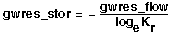 ,
,K r is the slope of the ground-water flow recession obtained from the semilog plot for discharge versus time.

shows that -log e Kr is equivalent to gwflow_coef in equation 1.
The ground-water outflow from a upslope reservoir (gwflow_out) to a downslope reservoir is calculated when gw_res_2_res_id > 0, with equation 1 written as
 ,
, gwflow_grad is relative gradient between an upslope and downslope reservoir, and
gwflow_fact is the average of the upslope and downslope HRU ground-water routing coefficients (gwflow_coef).
![gwflow_grad =[ [ hru_elev(up) - hru_elev(down)] divided by sum ] x gwfact_basin](../../images/gwflow_prms_min_darcy-6.gif)
hru_elev is mean elevation of the upslope and downslope reservoirs, in feet,
sum is average of the elevation differences between all of the pairs of upslope and downslope reservoirs, in feet, and
gwfact_basin is the inverse of a factor representing a relative distance between all of the pairs of the upslope and downslope HRU ground-water reservoirs. This factor is to help constrain the gwflow_grad values to be near one (unit gradient), which results in the gwflow_coef values being in the typical PRMS range of 0.1-0.0001.
For each ground-water reservoir, after gwres_flow is calculated and gwres_stor is reduced by that amount, gwres_stor is checked to determine if it is less than gwstor_min. If it is less than that quantity, it is made equal to gwstor_min. This minimum quantity adds additional water to the water budget that is not accounted for by precipitation during the simulation period. In high-relief mountainous terrain, much of the water stored in the rock materials is older water. Even if precipitation did not occur over several years, certain geologic materials have residual storage that can still provide water to a lower basin outflow point. For example, a larger basin with elevation differences of 1,000 to 7,000 feet may have an effective (low porosity) storage reservoir depth of 3,000 feet that was filled over millennia. This reservoir can drain to the basin outflow without any additional input from precipitation. This concept would also hold in wetter mountainous terrain over timescales of hundreds of years.
The movement of water through the ground-water reservoir to points beyond the area of interest or measurement is treated using a ground-water sink. The accretion to gwres_sink is computed by
 .
.For each ground-water reservoir, after gwres_sink is calculated and gwres_stor is reduced by that amount, gwres_stor is checked to determine if it is less than gwstor_min. If it is less than that quantity it is made equal to gwstor_min.
One or more ground-water reservoirs can be delineated in a watershed. More than one reservoir requires sufficient data to estimate initial storage volumes and routing coefficients. For small watersheds, only one ground-water reservoir is normally specified.
This module also computes weighted averages for gwres_stor , gwres_flow and gwres_sink for the basin.
Leavesley, G. H., Lichty, R. W., Troutman, B. M., and Saindon, L. G., 1983, Precipitation-runoff modeling system--User's manual: U. S. Geological Survey Water-Resources Investigations Report 83-4238, 207 p.
Linsley, R. K., Jr., Kohler, M. A., and Paulhus, J. L., 1958, Hydrology for engineers: New York, McGraw-Hill, p.151-155.
URL for this page is http://pubsdata.usgs.gov/pubs/of/2002/ofr02362/htdocs/gwflow-darcy/gwflow_prms_min_darcy.htm
Page contact: Mark Mastin (mcmastin@usgs.gov),
253-428-3600, ext. 2609
Last modified: Friday, 11-Jan-2013 03:19:45 EST
![]()
![]()