
Fact Sheet 2004–3061
June 2004
Figure 1. Well-numbering system.
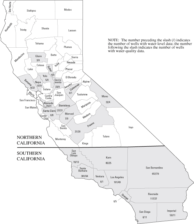
Figure 2. The number of wells, by county (shaded), for which data are avail...
The U.S. Geological Survey, Water Resources, in cooperation with Federal, State, and local agencies, obtains a large amount of data pertaining to the ground-water resources of California each water year (October 1–September 30). These data constitute a valuable database for developing an improved understanding of the water resources of the State. Beginning with the 1985 water year and continuing through 1993, these data were published in a report series entitled "Water Resources Data for California, Volume 5. Ground-Water Data." Prior to the introduction of this series, historical ground-water information was published in U.S. Geological Survey Water-Supply Papers.
In 1994, the Volume 5 Ground-Water Data report was discontinued, but data continue to be available in our databases. This Fact Sheet serves as an index to ground-water data for water year 2003. The 2-page report contains a map of California showing the number of wells (by county) with available water-level and water-quality data for water year 2003 (fig. 2) and instructions for obtaining this and other ground-water information contained in the databases of the U.S. Geological Survey, Water Resources, California District.
Because the geography and geology of California are so complex, ground-water conditions are difficult to summarize. Ground-water levels are affected by short- and long-term climatic conditions and also by ground-water withdrawals, irrigation returns, and other factors.
Measurements of water levels are made in many types of wells under varying conditions, but they are made using standard methods and equipment to ensure that these measurements are consistently accurate and reliable. All water levels in the California database are given in feet with reference to land-surface datum.
The quality of ground water ordinarily changes slowly; therefore, a single annual sampling usually is sufficient to define ground-water quality in most settings. If the quality of ground water is likely to change rapidly because of special circumstances, more frequent sampling may be done to identify the nature of the change.
Wells and springs in California are assigned numbers according to their location in the rectangular system for the subdivision of public land. For example, in the number 005S012E22P001M (fig. 1), the first four characters indicate the township (T. 5 S.), and the next four characters indicate the range (R.12 E.); the two digits following the range indicate the section (sec. 22); and the letter following the section indicates the 40-acre subdivision of the section. Within each 40-acre subdivision, the wells are numbered serially, as indicated by the last three digits. The final letter indicates the baseline and meridian designation as follows: H, Humboldt; M, Mount Diablo; S, San Bernardino. This 15-digit number is called the Local Number or State Well Number.
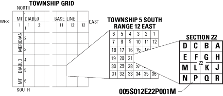
Figure 1. Well-numbering system.
Data may be accessed directly through the USGS National Water Information Website (NWISWeb) at:
http://waterdata.usgs.gov/nwis/
For other information on how to obtain data, send email or call: tchaltom@usgs.gov (916-278-3100) for northern California data; jahuff@usgs.gov (858-637-6823) for southern California data.
For more information on ground water in California please write to:
Julia A. Huff
Technical Information Specialist
U.S. Geological Survey, Water Resources Division
5735 Kearny Villa Rd., Suite O
San Diego, CA 92123
Access this fact sheet and other U.S. Geological Survey water resources information at: http://water.wr.usgs.gov
Document Accessibility: Adobe Systems Incorporated has information about PDFs and the visually impaired. This information provides tools to help make PDF files accessible. These tools convert Adobe PDF documents into HTML or ASCII text, which then can be read by a number of common screen-reading programs that synthesize text as audible speech. In addition, an accessible version of Acrobat Reader 6.0, which contains support for screen readers, is available. These tools and the accessible reader may be obtained free from Adobe at Adobe Access.
| AccessibilityFOIAPrivacyPolicies and Notices | |
 |
|