
INTRODUCTION TO THE SOUTHERN FLORIDA NAWQA STUDY UNIT
| The Everglades are remarkable for....the absolute purity of the water there, which contrary to popular idea, is clear as crystal....Alanso Skinner, Bird Lore, XIII, no. 6, Nov.-Dec. 1911. |
| Both these glade rivers (Miami and New Rivers) are singularly beautiful. Their waters, clear and limpid, are fringed on either shore by all the wild growths of the hammock...pine and prairie, reflecting every change of scene like mirrors.J.N. MacGonigle, 1896, The geography of the southern peninsula of the United States: National Geographic Magazine, v. 7, no. 12, p. 381394. |
In the mid-1800s southern Florida was a lush, subtropical wilderness of pine forest, hardwood hammocks, swamps, marshes, estuaries, and bays. Wetlands dominated the landscape. The region contained one of the largest wetlands in the continental United States, the Everglades, which was part of a larger watershedthe Kissimmee-Okeechobee-Evergladeswhich extended more than half the length of the Florida peninsula (fig. 1). Wetlands of the Everglades, Big Cypress Swamp, and Mangrove and Coastal Glades stretched continuously across much of the southern part of the peninsula south of Lake Okeechobee (fig. 1). To the north, much of the Flatwoods physiographic province also was wetlands; upland habitats were primarily on the narrow Lake Wales and Atlantic Coastal Ridges.
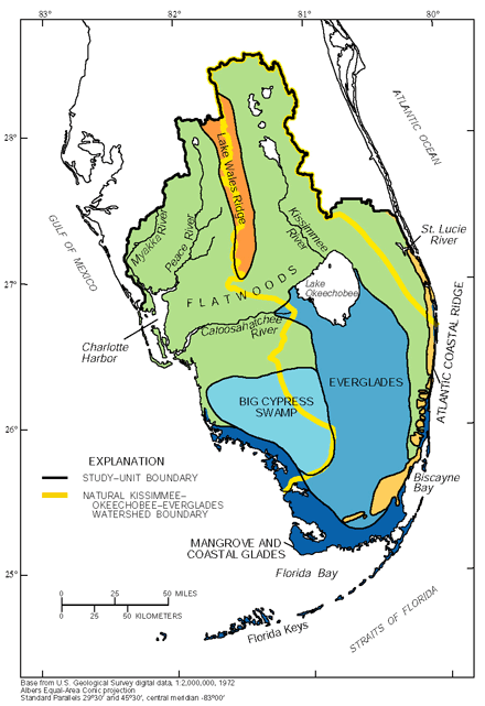 |
| Figure 1. Physiographic provinces of southern Florida. (Modified from Davis, 1943; Parker and others, 1955.) |
Freshwater in the Everglades and other wetlands generally moved as sheetflow in marshes, sloughs, and cypress strands. Numerous small streams and rivers near the coast, such as the Miami River, drained into mangrove forests and tidal waters and provided the freshwater that sustained the highly productive and abundant coastal fisheries around the southern end of the peninsula (McIvor and others, 1994).
The wetlands of southern Florida made much of the region inhospitable for human habitation. Settlers and developers in the late 1800s and early 1900s began to drain the wetlands for commercial and safety reasons. Loss of lives as a result of hurricane flooding in the 1920s accelerated drainage projects. Today, many of the regions original wetlands have been drained. Water in the region is now intensively managed, with more that 1,400 miles of primary canals and more than 100 water-control structures. The larger rivers, such as the Kissimmee and Caloosahatchee Rivers, have been canalized and controlled to enhance their ability to move water. About half the Everglades have been lost to drainage and development since the early 1900s; the remaining Everglades, included in the Everglades National Park (ENP), conservation areas, and the Loxahatchee National Wildlife Refuge, are protected from physical destruction, but it has been degraded by altered quantity, quality, and timing of freshwater inflows.
| The Southern Florida (SOFL) National Water-Quality Assessment study encompasses about 19,500 square miles. It is part of a regional ecosystem that includes coastal waters between Charlotte Harbor on the Gulf of Mexico and the St. Lucie River on the Atlantic Ocean and the lands that drain into these waters. The elevation in the study area ranges from about 300 feet above sea level to sea level along the coast. It includes a large and rapidly growing urban population (about 5 million people) along the Atlantic coast and a less rapidly growing population (over a million people) along the gulf coast, areas of intense agricultural development around Lake Okeechobee and along the southeastern edge of the Everglades, and vast regions of wetlands, including the Everglades National Park (ENP), Big Cypress National Preserve, and other parks, preserves, and conservation areas that are mostly in public ownership. Ground water from the shallow, highly porous Biscayne aquifer is the source of most of the drinking water for the densely populated southeast coast. |
Drainage and development of wetlands have adversely affected water quality and ecology throughout southern Florida. Water pumped into canals from agricultural lands commonly has high concentrations of nutrients and pesticides. The high nutrient concentrations and loads entering Lake Okeechobee and the Everglades from farms and cattle lands have degraded water quality. Phosphorus concentrations in Lake Okee-chobee have increased two and one-half times since the 1970s, and massive algal blooms have become more frequent and persistent. The increased nutrient loading to the Everglades is stressing native vegetative communities. Sawgrass, which is adapted to a low-nutrient environment, is being replaced by cattails in parts of the northern Everglades where nutrient loading has been excessive. Drainage and development also has resulted in loss of peat soils, contamination by pesticides, saltwater intrusion into aquifers near the coast, mercury buildup in the biota, fragmentation of landscape, loss of wetland functions, widespread invasion by exotic species, increased algal blooming, seagrass die-off, and declines in fishing resources in coastal waters.
| Everywhere and at all seasons of the year, the water in the glades is clear, pure, and though sometimes warm, palatable, without the least staleness or stagnancy. Edwin Asa Dix and Rev. John N. MacGonigle, Century Magazine, February 1905. |
An abundant and uncontaminated supply of freshwater was a primary environmental characteristic of southern Florida in predevelopment times. Increased human population and activity have brought not only increased need for water but also a decrease in water supply and deterioration in water quality. These changes in the hydrologic system, wrought by growth and development, are thought to be the major causes of the substantial declines in the health of the remaining natural ecosystem.
A consensus has begun to emerge among environmental groups and Federal and State agencies that southern Florida, and particularly the Everglades, should be restored to the extent possible to the predevelopment ecosystem. A first and primary step in this undertaking is the restoration of pre-development hydrologic conditions to the remaining natural system. Plans are to change the manmade water-conveyance system and restore the natural hydrologic cycle of the predevelopment Everglades as a means of contributing to overall ecosystem restoration.
 |
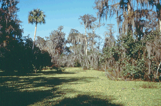 |
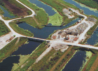
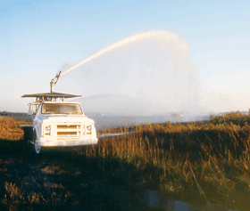
| Complex canal system in northern Everglades. | Northern Big Cypress Swamp. |
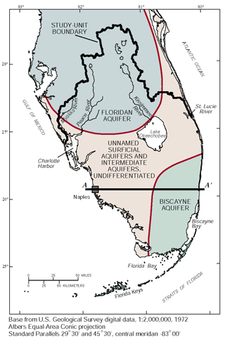
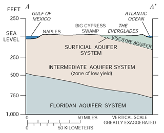
| Aquifers and Water Use Southern Florida, which is underlain by shallow marine carbonate sediments to depths of 20,000 feet, contains three major aquifer systems: the Floridan, the intermediate, and the surficial aquifer systems (figs. 2a,b). The confined Floridan aquifer system is the principal source of water for human use in the northern part of the south Florida area, but water from this aquifer is too mineralized for most uses in the southern part of the area. The semiconfining layers of the intermediate aquifer system, which overlies the Floridan, serves as the confining unit for the Floridan and is a source of freshwater for public supply along the gulf coast. The surficial aquifer system includes the highly permeable Biscayne aquifer, which is the principal source of potable water for the more than 5 million people in southeastern Florida. The Biscayne aquifer has been designated as a sole-source drinking-water supply by the USEPA. Most of the potable water supply in southern Florida is withdrawn from shallow aquifers, generally from wells less than 250 feet deep. Ground water supplied 94 percent (872 million gallons per day [Mgal/d]) of the water used by most of the 5.8 million people in the SOFL Study Unit in 1990. Water used for agriculture in 1990 (2,735 Mgal/d) was nearly evenly divided between ground-water and surface-water sources (Richard L. Marella, U.S. Geological Survey, written commun., 1990) |
|
||||
|
|
Annual rainfall in southern Florida ranges from about 40 to 65 inches. The east coast usually receives the greatest amount of rainfall, whereas the Florida Keys and areas near Lake Okeechobee and Charlotte Harbor usually receive the least. More than half the rainfall occurs from June through September and is associated with thunderstorms and tropical cyclones. Rainfall during the remainder of the year usually is the result of large frontal systems and is broadly distributed rather than localized. April and May typically have the least rainfall. Annual and seasonal rainfalls vary from year to year (fig. 3).
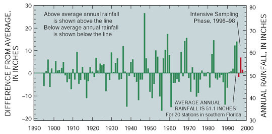 |
| Figure 3. Annual rainfall was above average during the 199698 sampling period. (Data from the National Oceanic and Atmospheric Administrations National Climate Center.) |
| HOW IS THE SOUTHERN FLORIDA NAWQA DIFFERENT FROM OTHER NAWQA STUDY UNITS? |
|
| Table of Contents || Previous Section || Next Section || Glossary U.S. Geological Survey Circular 1207 Suggested citation:
|
