AVAILABLE ONLINE ONLY
By James R. Degnan, Stewart F. Clark, Jr., Philip T. Harte, and Thomas J. Mack
Complete text of report is available as a PDF (6,004 KB)
Plate 1 is available in .gif format (110 KB)
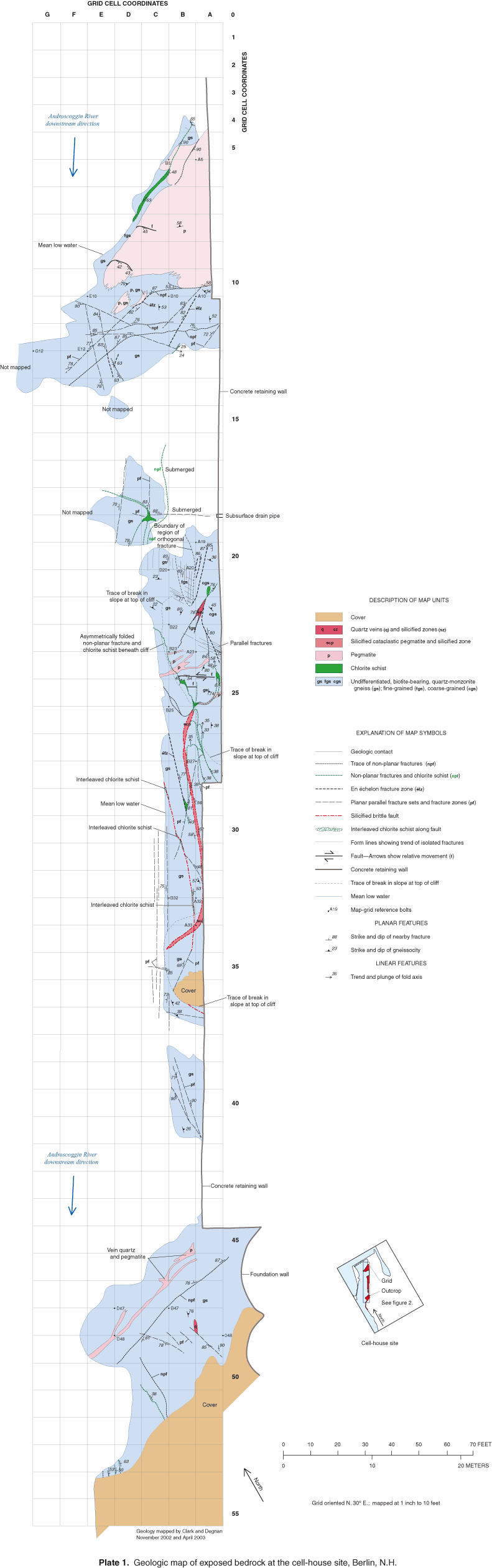
At the cell-house site, thin, generally less than 20-foot thick overburden, consisting of till and demolition materials, overlies fractured crystalline bedrock. Bedrock at the site consists of gneiss with thin discontinuous lenses of chlorite schist and discontinuous tabular pegmatite. Two distinct fracture domains, with principal trends to the west and northwest, and to the north, overlap near the site. The cell-house site shows principal trends common to both domains.
Gneiss is the most abundant rock at the site. Steeply dipping fractures within the gneiss terminate on subhorizontal contacts with pegmatite and on moderately dipping contacts with chlorite schist. Steeply northwest-dipping en Èchelon fracture zones, parallel joint zones, and silicified brittle faults show consistent strikes to the northeast. Gently east-dipping to subhorizontal fractures, sub-parallel to gneissosity, strike northeast.
The impermeable cap, barrier wall, and bedrock surface topography affect ground-water flow in the overburden. There is relatively little ground-water flow in the overburden in the capped area and a poor hydraulic connection between the overburden and the underlying bedrock over most of the site. The overburden beneath the cap may receive inflow through or beneath the barrier wall, or by flow through vertical fractures in the underlying bedrock beneath the barrier wall.
The bedrock aquifer near the river is well connected to the river and head difference in the bedrock across the site are large (greater than 13 ft). Horizontal hydraulic conductivities of 0.2 to 20 ft/d were estimated for the bedrock. Individual fractures or fracture zones likely have hydraulic conductivities greater than the bulk rock. Subhorizontal fractures occur at pegmatite contacts or along chlorite schist lenses and may serve as ground-water conduits to the steeply dipping fractures in gneiss. The effective hydraulic conductivity across the site is likely to be in the low range of the estimated values (0.2 ft/d). Ground water discharges to the river from the bedrock aquifer and is greatest during periods of large river stage fluctuations.
Abstract
Introduction
Site Description and History
Purpose and Scope
Geologic Setting
Methods
Geologic
Mapping and Analysis
Hydrogeologic
Analysis
Surface Water
Ground Water
Hydraulic Analysis
Geophysical Surveys
Ground-Penetrating
Radar
Two-Dimensional Resistivity
Borehole Geophysical Logs
Geologic Characterization
Berlin Area
Ductile Structures
Brittle Structures
Cell-House Site
Ductile Structures
Brittle Structures
Fracture
Zones
Faults
Fracture
Trends
Geologic Summary
Results of Hydrogeologic Analyses
Analysis of Surface and Ground-Water
Levels
Head Surfaces
and Hydraulic Connections
Hydraulic
Properties
Geophysical Surveys
Ground-Penetrating
Radar
Two-Dimensional
Resistivity
Borehole-Geophysical
Logs
Preliminary Hydrogeologic Characterization
Summary
Acknowledgments
References
Appendix 1 - Core Logs from Boreholes
Plate
Plate 1 Geologic map of exposed bedrock at the cell-house site, Berlin, N.H.
For more information concerning the research in this report, contact:
Brian Mrazik,
District Chief
USGS
361 Commerce Way
Pembroke, NH 03275
Web site: http://nh.water.usgs.gov
Phone: (603) 226-7807
Email: dc_nh@usgs.gov
Document Accessibility: Adobe Systems Incorporated has information about PDFs and the visually impaired. This information provides tools to help make PDF files accessible. These tools convert Adobe PDF documents into HTML or ASCII text, which then can be read by a number of common screen-reading programs that synthesize text as audible speech. In addition, an accessible version of Acrobat Reader 6.0, which contains support for screen readers, is available. These tools and the accessible reader may be obtained free from Adobe at Adobe Access.
| AccessibilityFOIAPrivacyPolicies and Notices | |
 |
|