
In cooperation with the U.S. Environmental Protection Agency
Geophysical Characterization of Fractured Bedrock
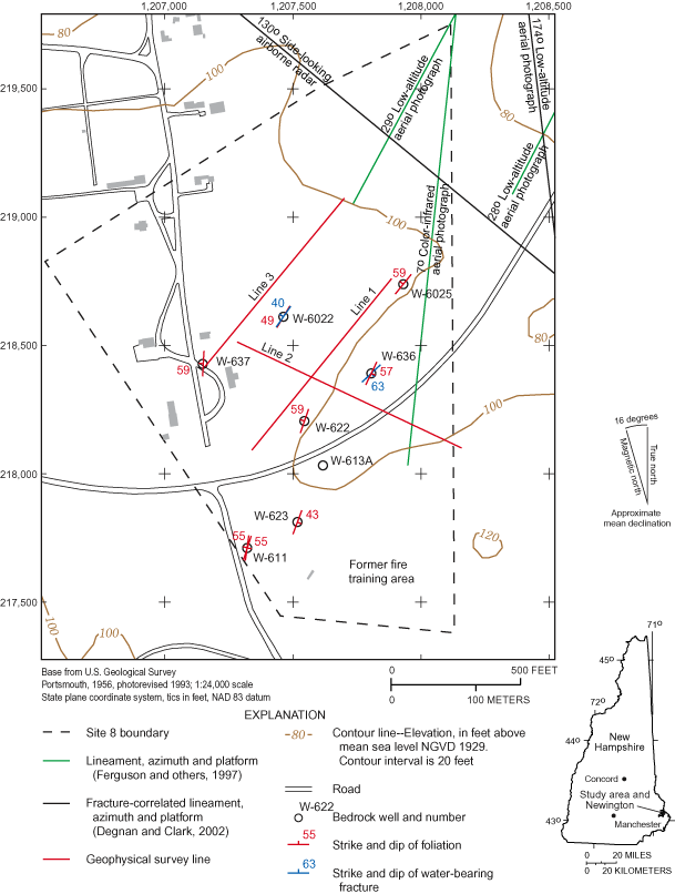
Figure 1. Location of the study area, geophysical survey lines, lineaments,...
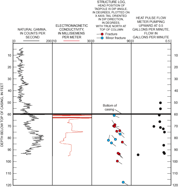
Figure 2. Borehole-geophysical logs of well W-611 in Newington, N.H. (Note:...
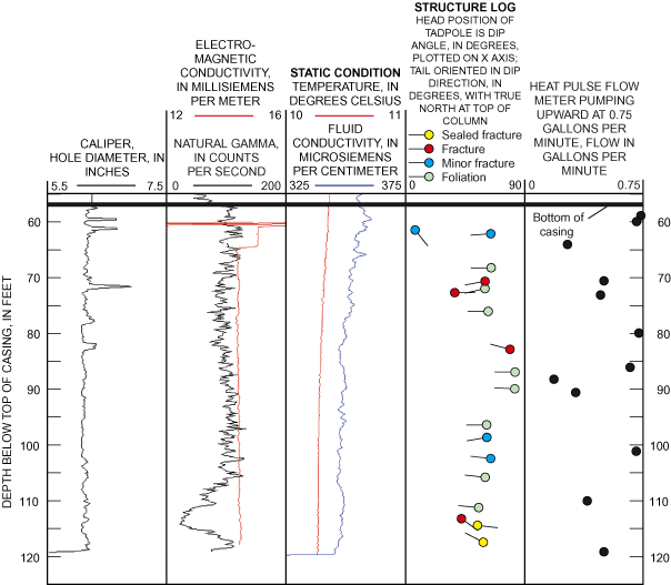
Figure 3. Borehole-geophysical logs of well W-613A in Newington, N.H. (Note...
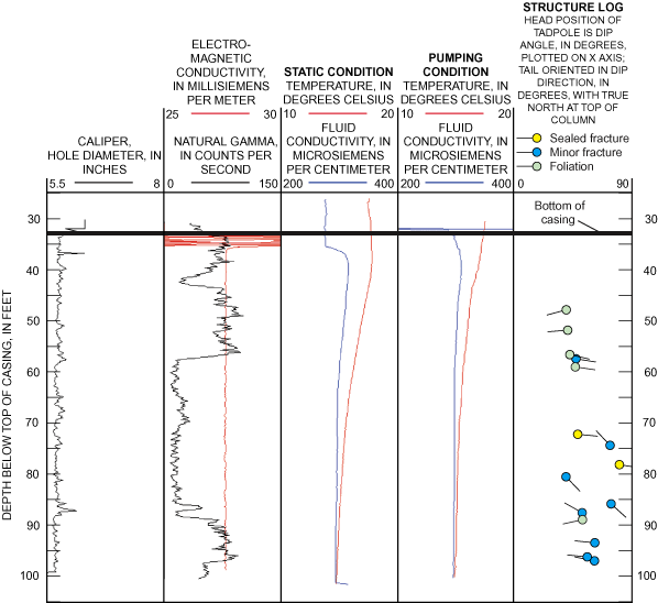
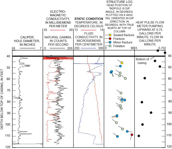
Figure 4. Borehole-geophysical logs of well W-622 in Newington, N.H. (Note:...
Figure 5. Borehole-geophysical logs of well W-623 in Newington, N.H. (Note:...
Figure 6. Borehole-geophysical logs of well W-636 in Newington, N.H. (Note:...
Figure 7. Borehole-geophysical logs of well W-637 in Newington, N.H. (Note:...
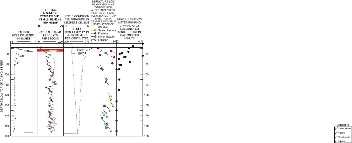
Figure 8. Borehole-geophysical logs of well W-6022 in Newington, N.H. (Note...
Figure 9. Borehole-geophysical logs of well W-6025 in Newington, N.H. (Note...
Figure 10. Schematic diagram of stereogram projections. The stereogram proj...
Figure 11. Lower hemisphere equal-area stereograms showing orientation with...
Figure 12. Cross sections showing inverted resistivity along geophysical su...
Table 1. Driller log information for selected bedrock wells at Site 8, form...
Table 2. Mean strike, dip azimuth, and dip of foliation in eight wells at S...
Appendix 1. Midpoint depth, dip azimuth, and dip based on geophysical logs f...
| Multiply | By | To obtain |
|---|---|---|
| Length | ||
| inch (in.) | 25.4 | millimeter (mm) |
| foot (ft) | 0.3048 | meter (m) |
| mile (mi) | 1.609 | kilometer (km) |
| Area | ||
| square foot (ft2) | 0.09290 | square meter (m2) |
| Flow rate | ||
| gallon per minute (gal/min) | 0.06309 | liter per second (L/s) |
Temperature in degrees Fahrenheit (°F) may be converted to degrees Celsius (°C) as follows:
°C=(°F-32)/1.8
Vertical coordinate information is referenced to the National Geodetic Vertical Datum of 1929 (NGVD 29).
Horizontal coordinate information is referenced to the North American Datum of 1983 (NAD 83).
Units of measurement
µs/m microsiemens per meter at 25° Celsius
° degrees
Borehole-geophysical logs collected from eight wells and direct-current resistivity data from three survey lines were analyzed to characterize the fractured bedrock and identify transmissive fractures beneath the former Pease Air Force Base, Newington, N.H. The following logs were used: caliper, fluid temperature and conductivity, natural gamma radiation, electromagnetic conductivity, optical and acoustic televiewer, and heat-pulse flowmeter. The logs indicate several foliation and fracture trends in the bedrock. Two fracture-correlated lineaments trending 28° and 29°, identified with low-altitude aerial photography, are coincident with the dominant structural trend. The eight boreholes logged at Site 8 generally have few fractures and have yields ranging from 0 to 40 gallons per minute. The fractures that probably resulted in high well yields (20–40 gallons per minute) strike northeast-southwest or by the right hand rule, have an orientation of 215°, 47°, and 51°.
Two-dimensional direct-current resistivity methods were used to collect detailed subsurface information about the overburden, bedrock-fracture zone depths, and apparent-dip directions. Analysis of data inversions from data collected with dipole-dipole and Schlumberger arrays indicated electrically conductive zones in the bedrock that are probably caused by fractured rock. These zones are coincident with extensions of fracture-correlated lineaments. The fracture-correlated lineaments and geophysical-survey results indicate a possible northeast-southwest anisotropy to the fractured rock.
Surface- and borehole-geophysical methods were used to determine the location and orientation of transmissive bedrock fractures at selected survey lines and boreholes at Site 8 (fig. 1) at the former Pease Air Force Base (PAFB) in Newington, N.H. Site 8 was a fire-training area for PAFB from 1961 to 1988. Mixtures of waste oils, solvents, and fuels were ignited in an open pit for fire-training purposes and extinguished after a few minutes. Some of the fuel mixtures leached to the water table. Contaminated ground water has been treated at this site since 1995. Additional information on the hydraulic characteristics of the fractured bedrock, including the flow pathways to wells, was needed to understand the potential fate and transport of contaminants in the bedrock. In this study, the U.S. Geological Survey (USGS), in cooperation with the U.S. Environmental Protection Agency, Region I (USEPA), conducted preliminary geophysical surveys during 1999 and 2000 at Site 8, and at some selected sites nearby, to characterize the bedrock beneath this area. Detailed borehole-geophysical surveys were used to characterize bedrock fractures and identify transmissive fracture zones. Surface-geophysical surveys were used to investigate whether lineaments identified by Degnan and Clark, Jr. (2002), and Ferguson and others (1997) indicated bedrock fracture zones and, if so, to estimate their location and dip.
Ground-water movement in fractured bedrock is one of least well understood areas of investigation in hydrogeology and is the subject of continued research by the USGS. This investigation will assist with site remedial activities by adding to the understanding of the fractured bedrock and its interaction with the regional ground-water flow system.
Numerous bedrock wells at Site 8 are used by the U.S. Air Force to characterize the geohydrology, monitor the contaminant plume, and operate a contaminant-extraction system. Contamination at this site is from waste oils, solvents, and jet fuel that were poured onto the ground and subsequently leached to the water table between 1961 and 1988. A ground-water-contaminant plume formed from this leaching was composed of volatile organic compounds (VOCs) including benzene, napthalene, alkylbenzenes, cis-1,2-dichloroethene, and vinyl chloride (Bechtel Environmental, Inc., 2000). The downgradient extent of the northerly trending plume included wells W-622, W-636, and W-6022 (fig. 1) (Bechtel Environmental, Inc., 2000, fig. 2).
The purpose of this report is to present the results of borehole-geophysical logging and direct-current resistivity surveys that were used to characterize the bedrock and to determine the location and orientation of transmissive zones in the bedrock at Site 8 at the former PAFB, in Newington, N.H. Borehole-geophysical logs including caliper, fluid-temperature and resistivity, electromagnetic conductivity, natural gamma, acoustic televiewer, optical televiewer, and heat-pulse flowmeter were collected at eight wells. Direct-current resistivity surveys, using dipole-dipole and Schlumberger arrays, were performed along three survey lines to investigate whether previously identified lineaments are indicative of fracture zones in the bedrock. The methods used in this investigation have transfer value to other fractured-bedrock research site investigations.
Site 8 is on the northern end of a large kame plain (Bradley, 1964) consisting of stratified glacial sand and gravel with some marine sand, silt, and clay. Till discontinuously underlies stratified sediments at the site. Saturated overburden occurs in a northeast-trending depression (in the direction of wells W-623 and W-636; fig. 1) in the bedrock surface. The overburden aquifer was unsaturated in the southeast and northwest (at wells W-6022 and W-637) areas of the site. Ground-water flow in the overburden was to the northeast with about a 4-foot difference in hydraulic head (head) across the site (Bechtel Environmental, Inc., 2000; fig. 3). As of 2000, extraction wells in the overburden near W-636 and W-613A have caused localized cones of depression in the overburden but have had little effect on bedrock ground-water levels across the site (Bechtel Environmental, Inc., 2000; fig. 3). The ground-water flow direction in bedrock was to the northwest with about a 12-foot head difference across the site (Bechtel Environmental, Inc., 2000; fig. 3).
Bedrock in the study area is described by Novotny (1969) and is composed of the Eliot Formation, which consists primarily of slate, phyllite, schists, and quartzite. The northeast-southwest-trending Eliot Formation is a limb of a regional overturned anticline, with limbs dipping to the southeast and northwest (Lyons and others, 1997). Foliation in the study area (Novotny, 1969; pl. 1) trends northeast with a vertical to 75° northwest dip. Numerous fine-grained diabase dikes range from several feet to tens of feet in width, and have been observed in wells drilled at Site 8. The margins of these dikes are often fractured. Drillers' logs from Site 8 generally report dark gray to green phyllite, with lesser amounts of schist, and quartz veins (Roy F. Weston, Inc., 1992).
Tectonic compressional events in the Paleozoic Era caused deformation of the crystalline rock in the area. Major faults (including the Portsmouth Fault and Great Common Fault Zone) and small-scale faulting are mapped in southeastern New Hampshire (Novotny, 1969; and Hussey and Bothner, 1995). Novotny (1969) measured steeply dipping fractures in the Eliot Formation trending north 26° east (or 26° in azimuthal direction). The steeply dipping fracture-family peaks (in azimuthal direction from true north) identified from measurements in outcrops of the Eliot Formation within a 10,000-ft2 region were 28°, 37°, 144°, and 168° (Degnan and Clark, 2002).
A lineament analysis that included the study area was done by the USGS as part of a statewide bedrock-mapping assessment (Ferguson and others, 1997; Moore and others, 2002). Further regional analysis, including identifying remotely sensed lineaments that correlate with bedrock fractures (fracture-correlated lineaments), was done by Degnan and Clark (2002). Certain types of lineaments, particularly certain fracture-correlated lineaments, have been correlated with high-yielding wells, or more transmissive bedrock in New Hampshire (Moore and others, 2002). Lineaments identified at or near the study area are shown in figure 1. Of particular interest is a fracture-correlated lineament interpreted from low-altitude areal photographs oriented 29°, immediately north of Site 8. Projecting this lineament along its trend results in a lineament that intersects well W-6022. An approximately parallel, 28° fracture-correlated lineament is 550 ft to the southeast. The 28° lineament corresponds to the orientation of the depression in the bedrock surface at Site 8. A side-looking airborne radar (SLAR) lineament trending 130° is northeast of the site, and a lineament trending 7°, identified by color-infrared photography, is on the east side of the site. Lineaments in this report are reported in azimuthal direction as degrees east of north (true north).
Geophysical surveys (Keyes, 1990; and Zohdy and others, 1974) take advantage of physical changes in rock properties, such as variations in electrical resistivity caused by water-filled fractures, or variations in acoustic velocity at a fracture interface, to help identify fractures in bedrock. Borehole- and surface-resistivity surveys were used in this study to characterize fractured bedrock. Indications of transmissive fracture zones may be supported by observation of other physical properties, such as water movement in a borehole or differences in fluid properties in a borehole. Integration of a variety of geophysical methods often is necessary to characterize bedrock and identify transmissive fractures at a site.
The U.S. Environmental Protection Agency selected 8 wells (table 1) for geophysical characterization based on well depth and location within Site 8. Borehole-geophysical logs were used to identify transmissive fractures and measure bedrock foliation and properties at the site. Open, sealed, and minor fractures also were measured because the methods used may not identify all transmissive fractures. Fractures sealed at the borehole wall may be open elsewhere because of inconsistencies in fracture fillings, such as calcite or quartz, or varying aperture. Borehole geophysical logs including caliper, fluid temperature and resistivity, electromagnetic (EM) conductivity, natural gamma, acoustic televiewer (ATV), optical televiewer (OTV) and heat-pulse flowmeter, were collected between September 1999, and May 2001 as part of this study. An exception is well W-636, at which video and heatpulse flowmeter logs were collected in 1997 (Carole Johnson, U.S. Geological Survey, written commun., 1997), and an ATV log of W-636 was collected in September 1999, by Mark Blackey of Geophysical Applications, Inc. (Michael Daly, U.S. Environmental Protection Agency, written commun., October 1999). Geophysical-log depths are referenced to the top of the steel well casing. All data are maintained on file in the USGS New Hampshire/Vermont District office in Pembroke, N.H.
Methods used to collect a basic suite of logs (natural gamma, caliper, fluid temperature, fluid conductivity, and EM conductivity) are described by Keyes (1990). Paillet and others (1996) describe methods for collecting measurements of vertical borehole flow in fractured rock using the heat-pulse flowmeter. Methods and equipment for borehole ATV and OTV well-imaging surveys are described by Johnson (1996) and Johnson and Dunstan (1998). These methods were used in similar detailed fractured-bedrock studies in southeastern New Hampshire (Johnson and others, 1999; Mack and others, 1998). Bedrock characteristics (orientations of foliation and fractures) were primarily identified by OTV and supplemented by data from the ATV logs. The transmissive fractures were identified by changes, or anomalies, in fluid temperature and conductivity logs and through the use of heat-pulse flowmeter logs.
The heat-pulse flowmeter measures upward or downward flow at a point in the borehole. Interpretation of borehole flowmeter measurements requires that the flowmeter log be interpreted in context with other logs. The geophysical and drillers logs are viewed collectively to determine which fracture, or fracture zone, the flow measured at a point in the open borehole is most likely attributed to. Interpretation, therefore, requires viewing multiple consecutive flowmeter measurements, up or down the borehole, in conjunction with other logs. Heatpulse flowmeter measurements were made under ambient (nonpumping) conditions and then while imposing a stress (pumping). Stressed heatpulse flowmeter logs were collected with the well pumped at about 1 gal/min from a pump placed near the top of the well. The transmissivity of an open borehole is large relative to that of individual fractures in crystalline rock; therefore, demand for water by the pump is met by the most transmissive fractures first (Shapiro, 2002). Fractures that produce relatively little water relative to other fractures in that borehole may not be identified.
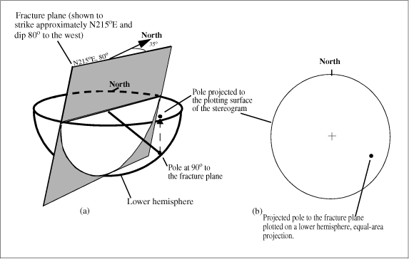
The orientation of features identified in the borehole surveys, unlike lineaments, are described using "right-hand rule" terminology. By this method, the strike of the feature is presented in azimuth degrees (from true north) where the dip of the plane is to the right of the strike azimuth. Therefore, a fracture strike with a north-south orientation will be presented as 180° east of true north if the fracture plane dips west, or 0° if the fracture plane dips east. The orientation of groups of features are presented using stereograms to graphically illustrate fracture or foliation patterns. The use of stereograms provides a means to visualize the orientation of borehole features to search for fracture or foliation trends.
[Data modified from Roy F. Weston, 1992; No., number; fig., figure; in., inch; LSD, land-surface datum; gal/min, gallons per minute; <, less than]
| Well No. (fig. 1) | Top of casing (elevation in feet as reported) | Borehole diameter (in.) | Depth to bedrock (feet below LSD) | Open interval (feet below LSD) | Noted water-bearing fracture depths, in feet; and yields, in gallons per minute (in parenthesis) | Total well yield (gal/min) | Rock type |
|---|---|---|---|---|---|---|---|
| W-611 | 113.60 | 8 | 22 | 33–100 | No yield detected | 0 | Slate |
| W-613A | 112.36 | 18 | 25 | 55–94 | 100 (<1) | <1 | Slate |
| W-622 | 106.77 | 6 | 19 | 32–173 | 22–23(?), 30–31(?), above 121 ft (0.25), 133–165 (0), 165–173 (4) | 4 | Basalt |
| W-623 | 112.05 | 6 | 39 | 55–125 | Possible 120–125 (6) | 6 | Gneiss |
| W-636 | 102.84 | 16 | 26 | 58–122 | 72 (1–2), 80 (1–2), 91–94 (20–40) | 20–40 | Schist |
| W-637 | 111.96 | 6 | 30 | 59–120 | 70 (1), 90 (3), 97(?) | 3 | Schist |
| W-6022 | 105.06 | 6 | 22 | 41–117 | 37–39.6 (?), above 97 (<0.5), 112–117 (25–30) | 25–30 | Phyllite |
| W-6025 | 100.63 | 6 | 57 | 75–158 | Could not determine | 6 | Diabase, phyllite |
1 Finished with 2-in.-diameter polyvinyl-chloride casing.
In crystalline bedrock of New Hampshire, variations in electrical resistivity are likely related to changes in lithology, water chemistry, and increases in water content of large fractures or fracture zones. Resistivity surveys measure the composite electrical resistivity of the subsurface. Direct current is induced into the ground between two current electrodes and the voltage is measured across two potential electrodes. A resistance value is obtained by dividing the measured voltage by the induced current. Various survey-electrode-array configurations and data-processing techniques can be used to differentiate survey data into interpreted geologic sections. An apparent resistivity is calculated from a resistance value and geometric factors that account for the electrode spacing and array type (arrangement of current and potential electrodes in relation to each other). Resistivity measurements were made with both Schlumberger and dipole-dipole array (Zohdy and others, 1974) configurations using 28 electrodes with a 10-m (32.8 ft) electrode spacing.
The apparent resistivity measured is an average resistivity of all materials surveyed to the depth of the investigation (survey depth generally is about 20 percent of the length of the survey, depending on the factors mentioned above). Apparent resistivity values were inverted to differentiate the effects of shallow materials from the true resistivity values of deep materials. Lithologic logs from drilling at the site were used to aid in interpretation of the overburden materials and the depth to top of bedrock at the survey lines. Topographic relief at each electrode along a survey line is accounted for in the data processing. Data were processed using RES2DINV version 3.42 (Loke, 2000) to produce inverted resistivity sections from apparent resistivity measurements. Resistivity sections interpreted from dipole-dipole surveys are presented in this report because they provide greater investigation depth, and lateral resolution, than the Schlumberger surveys. Processed Schlumberger-array resistivity surveys were used to check the near-surface results and are on file in the New Hampshire/Vermont District Office.
Borehole geophysical logs were collected in wells W611, W-613A, W-622, W-623, W-636, W-637, W6022, and W-6025 (table 1) at Site 8. Three direct-current resistivity surveys were used to determine large-scale bedrock-fracture locations and dip directions in two-dimensional profiles.
Plots of log data for eight wells (figs. 2–9, in back of report) identify the location and orientations of fractures and foliations, changes in water chemistry, changes in lithology, and vertical flow in the well. In the caliper log, a fracture appears as an increase in the borehole diameter. In figures 2, 4, 5, and 7–9, large spikes or enlargements in the caliper log usually correlate with fractures identified in the televiewer logs.
The caliper logs show a general low density of fracturing with depth in wells W-611 (fig. 2), W-637 (fig. 7), and W-6025 (fig. 9). Well W-623 (fig. 5) shows prominent caliper deflections in a fractured zone from 93 to 100 ft, and another zone from 68 to 77 ft. In crystalline rock, the EM conductivity log can identify highly fractured rock (Mack and others, 1998), which may be attributed to alteration minerals formed in association with ground-water flow at transmissive fractures. Of the wells logged, however, only W-623 (fig. 5) indicates fracture zones identified by the EM conductivity log.
Potential zones of water inflow and outflow were assessed by fluid temperature and conductance logs under ambient conditions at all wells. Fluid logs were collected while pumping at wells W-611, W-623, and well W-622. Potential fracture zones were assessed with flowmeter logs. At most wells, ambient flow was not detected with the fluid and heat-pulse flowmeter logs; therefore, ambient heat-pulse flowmeter logs were not included in the figures. Several of the flowmeter logs (W-623, W-622, W-636, W-637, W-6022, and W-6025) indicated minor apparent outflows under pumping conditions. Apparent outflows are indicated by a drop in flow in adjacent measurements, logged from bottom to top of the borehole, during pumping. Flow bypassing the flowmeter may be suspected where ambient measurements showed no flow. Fluctuations in the pumping rate or a poor seal between the flowmeter and the rough borehole wall may also affect flowmeter measurements.
Specific observations concerning the logs of individual boreholes, shown in figures 2–9, follow in the next few paragraphs. The location (depth) and orientation (dip azimuth and dip) of individual fractures and foliation are presented by well in Appendix 1 (note that the strike of a feature is 90° from the dip azimuth).
The logs of well W-611 (fig. 2) indicate few fractures, no ambient or pumped flow was detected, and the gamma log indicates lithologic changes (discussed in the next paragraph) at 57 and 87 ft (fig. 2). Logs collected for well W-613A (fig. 3) are limited because the borehole is cased with 2-in diameter polyvinyl chloride (PVC).
The logs for W-622 (fig. 4) indicate some fracturing (based on the caliper log) and some lithologic contrasts (based on the gamma and optical logs). The borehole appears to intersect a dike, based on the optical and drillers logs, in two zones (60–64 and 84–100 ft) that are clearly outlined by a low gamma response (fig. 4). From inspection of the optical log, the upper zone (60–64 ft) is clearly a dike whereas the lower zone (84–100 ft) is less distinct and may contain other lithologies. It is undetermined if a low gamma response is a consistent indicator of a dike. Some contact-parallel fracturing (strike 6°, dip 65° west) is indicated at the top of the upper dike (60–64 ft). The lower dike (84–100 ft) has a number of roughly north-striking fractures. Most of the inflow, measured under pumping conditions, appears to be associated with a fracture just below the base of the lower dike at 103 ft (strike of 5° and westerly dip of 59°).
A fracture zone in W-623 (fig. 5) measured by the caliper log from 93 to 100 ft correlates with a strong EM response; however, flow was not detected in this zone. Deviations in the fluid-conductivity log under pumping conditions indicate slight inflows at about 69 and 83 ft. On the basis of flowmeter logging, inflows appear to be from zones at about 83 ft, 69 ft, and at the base of casing (59 ft). An inflow between 62 ft and the base of the casing was measured by the flowmeter while pumping at a rate of 1 gal/min. This inflow, which is probably at the base of the casing, could be the result of leakage at the casing and bedrock seal or the casing being set at a transmissive fracture zone 16 ft into bedrock.
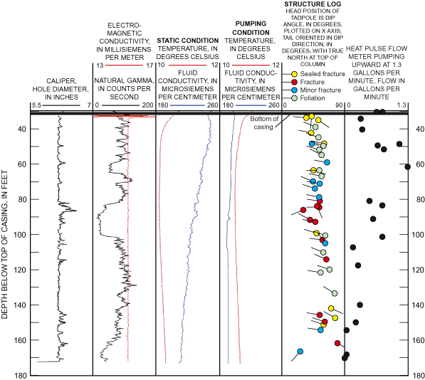
Wells W-636 (fig. 6) and W-6022 have reported yields of 20 to 40 and 25 to 30 gal/min respectively, (Roy F. Weston, Inc., 1992) and are the highest-yielding wells logged at Site 8. Well W-636 was entirely PVC-cased at the time of this investigation; therefore some logs are not available (caliper and fluid logs) and others (acoustic televiewer, heat-pulse flowmeter) are reported from previous investigations as noted in the Geophysical Methods section. W-636 data presented in Appendix 1 are from televiewer observations and foliations and fractures may be undifferentiated. There are three transmissive fractures in well W-636. Two transmissive fractures under pumping conditions are at 92.8 and 93.5 ft, with strikes of 51° and 47° and dips of 60° and 63°, respectively (Appendix 1). This fracture zone accounts for most of the well yield (20 to 40 gal/min) as indicated by drillers' (table 1) and heatpulse flowmeter logs (fig. 6). The other transmissive fractures, based on drillers' and flowmeter logs, appear to be at 70 ft with a strike of 28° (dip 52°), and at 81 ft with a strike of 231° (dip 54°).
The logs for well W-637 (fig. 7) indicate that there are a few fractures in the upper part of the well (61, 62, and 73 ft) and no ambient flow. Flow was measured in the well with pumping; however, even with heat-pulse flowmeter measurements, it was difficult to interpret where inflows were occurring.
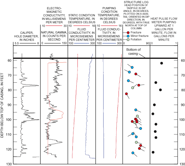
Fracture zones in W-6022 (fig. 8) occur throughout the open borehole, most notably from 90 to 95 ft. From 49 to 55 ft, a fracture zone is indicated by inflow, outflow, fluid property changes, and caliper-measured diameter increases. Well W-6022 shows fluid-conductance deviations, as well as slight fluid temperature changes, at 48, 49, 55, 56, 78, 107, and 110 ft. Under pumping conditions, the flowmeter log indicates minor inflows at the base of the well, at the fractures at 109 or 105, 92, and 55 ft; just below the bottom of casing at 43 ft; and possibly from the fractures at 78 and 79 ft. In well W-6022, a relatively large fluid-conductivity contrast (about 40 µS/cm) makes minor inflows appear prominently in the fluid log. About one half of the measured flow appears to be from the upper bedrock from fractures at 55 or 50 ft. Pumping conditions revealed three transmissive fracture zones in well W-6022 (fig. 8). A minor inflow occurred at a fracture at 92 ft, striking 168° (dip 39°). A fracture at 55 ft, with a strike of 68° (dip 21°), nearly coincides with a fracture striking 79° (dip 23°). The major producing zone from the drillers' log (25–30 gal/min at 112 to 117 ft) was associated with fluid-log deviations and is probably related to fractures at 109 and 111 ft with strikes of 109° (dip 82°) and 215° (dip 40°), respectively.
Well W-6025 (fig. 9) was the only other well logged where possible inflow was indicated at the base of the well casing. Deviations in the fluid-conductivity log are at depths of 79, 83, 88, and 106 ft. Inflow to this well, identified by flowmeter logging under pumping conditions (0.5 gal/min), was in the upper open interval from about 92 ft to the casing at 75 ft. The open interval at the top of the well, from 75 to 77 ft, is the most fractured area of the borehole and, from inspection of the optical log, may represent a dike with a strike of 17° (dip 73°). This zone corresponded with low gamma log response, a possible indicator of a mafic dike, and is bounded by fractures (74.5–77.5 ft, Appendix 1). The bottom of the casing, which is set 18 ft into bedrock, coincides with the transmissive fracture zone. It is undetermined whether the inflow at the base of the casing is from leakage at the seal between the casing and bedrock, or from the fracture zone.
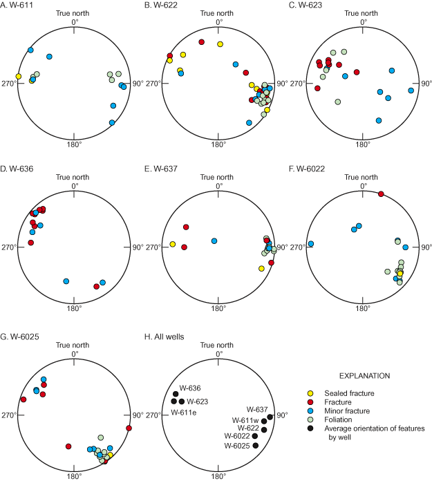
Patterns in foliation and fracture orientations in the boreholes are illustrated in lower-hemisphere, equal-area projections of the poles to fracture planes, called stereograms. An example of stereogram interpretation is presented in figure 10 modified from Johnson and others (1999). In the stereograms (fig. 11A–G), each fracture or foliation plane is represented as a point. The point is the intersection of the pole to the fracture or foliation plane and the lower hemisphere. This intersection is projected up to the equatorial (plotting) surface. For example, in the stereogram for well W-637 (fig. 11E), a near-horizontal fracture is indicated by the point near the center of the stereogram, whereas the group of poles towards the right outer edge of the stereogram represent predominantly north-south striking fractures or foliation with a steep, near-vertical westerly dip (average dip direction of 273° and average dip of 68°).
The foliation and fracture logs from Site 8 boreholes show distinct patterns. The lithology (bedding planes and contacts) at the wells generally have a consistent orientation. For example, the strikes of foliations identified in boreholes W-637 (fig. 11E), W-6022 (fig. 11F), and W-6025 (fig. 11G) are grouped in tight clusters. The orientation of foliations in each well indicated little variation; therefore, the average dip direction (for groups of points), and apparent strikes of foliations were calculated and are presented in table 2 and figure 11H. Because there were few fractures and they cannot be readily grouped, average fracture orientations were not calculated. The foliation at wells W-622, W-637, W-6022, and W-6025 has consistent south to southwest strikes of 183°, 198°, 210°, and 219°, respectively. Other wells on the west side of Site 8 (W-611 and W-623) had features that strike to the northeast and dip southeast. These features have the same southwest-northeast trend but dip in different directions. Well W-611 is unique in that bedrock foliation trends nearly north-south (8° to 17°) and dips both to the east and west (fig. 11A) controlled by lithologic changes as indicated by the gamma log at depths of 57 and 87 ft (fig. 2). The fractures identified in well W-623 (fig. 11C) had a northeast strike (200°) and a dip to the southeast. The wells on the northeast side of the site (W-6022 and W-6025; fig. 1) have foliation striking more southwest to northeast (210–219°) than the foliation in wells (W-623, W-637, and W-611) on the southwest side of the site (with average nearly north-south foliation strikes of 20°, 183°, and 188°, respectively). The orientations of identified fractures were generally close to those of the foliations but were not as consistent. For example, well W-6025 (fig. 9) has a tight cluster of foliation orientations but the identified fractures were not tightly clustered (fig. 11G).
[--, not calculated]
| Foliation | |||
|---|---|---|---|
| Well | Strike (degrees) | Dip azimuth (degrees) | Dip (degrees) |
| 1W-611 | 17 | 107 | 55 |
| 2W-611 | 188 | 278 | 55 |
| W-622 | 198 | 288 | 59 |
| W-623 | 20 | 110 | 43 |
| 3W-636 | 26 | 116 | 57 |
| W-637 | 183 | 273 | 68 |
| W-6022 | 210 | 300 | 49 |
| W-6025 | 219 | 309 | 59 |
| Average | 20 | -- | 56 |
1 East-dipping foliation in W-611.
2 West-dipping foliation in W-611.
3 Data from reported acoustic televiewer log, fractures are undifferentiated from foliation.
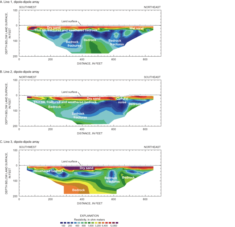
Dipole-dipole and Schlumberger arrays were used to characterize the electrical resistivity of overburden, bedrock, and bedrock-fracture zones through analysis of inverted resistivity data. Large-scale fractures or fracture zones in bedrock appear as electrically conductive anomalies in the resistivity-inversion cross sections presented in figure 12. The inversion profiles are interpreted to a depth of approximately 180 ft using the dipole-dipole array. Unsaturated sand is apparent in the sections as an electrically resistive layer near the surface. Directly below the unsaturated sand is generally a relatively thin (20 to 60 ft), electrically conductive layer consisting of saturated sands and till or weathered bedrock. Competent, or relatively less fractured bedrock, appears as electrically resistive areas beneath the weathered bedrock, whereas fractured bedrock appears as electrically conductive areas (fig. 12).
A relatively thin layer of electrically conductive till overlies electrically conductive fractured or weathered bedrock at line 1 and 2 (fig. 12a, b). Although there is some till present, based on the lithologic logs, it is not discernible from saturated sand, weathered bedrock, and fracture zones in the resistivity-inversion results. Saturated sand appears as an electrically conductive zone at the northeast end of line 1. A bedrock trough in that area extends below the water table and contributes to high electrical conductivities. Unfractured, competent bedrock may appear more conductive in the survey results than it actually is as a result of the effect of the overlying conductive materials.
Fracture zones extending into the bedrock, with an apparent northeast dip, are centered at 350 and 620 ft along survey line 1 (fig. 12a). Results from line 2 (fig. 12b) indicate two fracture zones that intersect each other at the bedrock surface. The zone at 380 ft (fig. 12b) has an apparent northwest dip and correlates with fracture locations and orientations in well W-622.
This zone may represent the extension of the 29° lineament shown in figure 1. Although the 29° lineament projects near W-6022, lineament locations cannot be plotted with precision. The second possible fracture zone on line 1 is at the 640 ft mark along the survey line. The zone correlates with the 28° lineament (fig. 1) and the similarly northeast-trending depression in the bedrock surface. This zone is likely related to the southeast-dipping fracture zone identified in W-636. Because the electrically conductive anomaly at 640 ft in line 2 may be influenced by electrical interference from conductive pore water from seasonal road-salt application, its apparent dip could not be confidently interpreted. In resistivity line 3 (fig. 12c), a bedrock-fracture zone with an apparent northeast dip is interpreted as intersecting the bedrock surface at the 570 ft mark along the line.
Surface- and borehole-geophysical methods were used to characterize the fractured bedrock and to identify and characterize transmissive fractures at Site 8 at the former Pease Air Force Base in Newington, N.H. The study was performed by the U.S. Geological Survey, in cooperation with the U.S. Environmental Protection Agency. The study results will be used to increase understanding of potential contaminant flow paths to wells in the bedrock. Wells at the site penetrate phyllite, schists, and quartzite of the Eliot Formation. Bedrock foliation has a fairly uniform north to northeast strike (average strike of 20°) with an average dip of 56°. In general, most fractures are oriented parallel to the foliation (northeast-southwest) and are steeply dipping. In two wells, W-622 and W-6025, increased fracturing appears to be associated with dikes. Two fracture-correlated lineaments (with strikes of 28° and 29°) delineated in previous investigations can be projected into the study area and have approximately the same orientation as the structural trend and the foliation and fractures measured. The fracture-correlated lineaments and regional structure correlation may indicate the presence of a regional northeast-southwest anisotropy to the fractured rock.
Drillers' and borehole-geophysical logs indicate that the bedrock penetrated by the wells is not highly fractured. None of the wells showed measurable flow in the borehole during ambient (nonpumping) conditions. Fractures at wells W-636 and W-6022 were highly transmissive (yields are 20 gal/min or greater) and major fracture zones were present in the open bedrock interval of those wells. The fractures that contribute a majority of the yield to these wells strike northeast-southwest (215º, 47º, and 51º).
Surface-resistivity surveys indicate fracture zones and possibly weathered rock near the bedrock surface. Shallow fracturing is interpreted through much of the survey lines; however, deep fracturing appears to have a narrower distribution then the shallow fracturing. The resistivity surveys support indications that the two fracture-correlated lineaments (with strikes of N26º and 29ºE) extending into Site 8 are possible bedrock-fracture zones.
The authors express their appreciation to Martin Mistretta, Bectel, Inc., for providing assistance throughout various field activities at Site 8. Appreciation is also extended to Scott Hilton, New Hampshire Department of Environmental Services, and Michael Daly, U.S. Environmental Protection Agency, for providing considerable background and historical information on Site 8.
Bechtel Environmental, Inc., 2000, Site 8, Fire department training area (FDTA) 2: Oak Ridge, Tenn., Remediation system fourth-year operations report, April 2000, 23 p.
Bradley, Edward, 1964, Ground-water resources of southeastern New Hampshire, U.S. Geological Survey Water-Supply Paper 1695, 80 p.
Degnan, J.R., and Clark, S.F., Jr., 2002, Fracture-correlated lineaments at Great Bay, southeastern New Hampshire: U.S. Geological Survey Open-File Report 02-13, 1 sheet, scale 1:24,000, 14 p.
Ferguson, E.W., Clark, S.F., Jr., and Moore, R.B., 1997, Lineament map of area 1, of the New Hampshire bedrock aquifer assessment, southeastern New Hampshire: U.S. Geological Survey Open-File Report 96-489, 1 sheet, scale 1:48,000.
Hussey, A.M., and Bothner, W.A., 1995, Geology of the coastal lithotectonic belt southwest Maine and southeast New Hampshire, in New England Intercollegiate Geological Conference, 87th annual meeting, Boston, Mass: Guidebook to field trips in southern Maine and adjacent New Hampshire, 20 p.
Johnson, C.D., 1996, Use of a borehole color video camera to identify lithologies, fractures, and borehole conditions in bedrock wells in the Mirror Lake area, Grafton County, New Hampshire, in Morganwalp, D.W., and Aronson, D.A., eds., U.S. Geological Survey Toxic Substance Hydrology—Proceedings of Technical Meeting, Colorado Springs, Colo., September 20–24, 1993: U.S. Geological Survey Water-Resources Investigations Report 94-4015, v. 1, p. 89–94.
Johnson, C.D., and Dunstan, A.H., 1998, Lithology and fracture characterization from drilling investigations in the Mirror Lake area, Grafton County, New Hampshire: U.S. Geological Survey Water-Resources Investigations Report 98-4183, 216 p.
Johnson, C.D., Dunstan, A.H., Mack, T.J., and Lane, J.W., Jr., 1999, Borehole-geophysical characterization of a fractured-bedrock aquifer, Rye, New Hampshire: U.S. Geological Survey Open-File Report 98-558, 61 p.
Keyes, W.S., 1990, Borehole geophysics applied to ground-water investigations: Techniques of Water-Resource Investigations of the United States Geological Survey, chap. E2, 150 p.
Loke, M.H., 2000, Electrical imaging surveys for environmental and engineering studies, A practical guide to 2-D and 3-D surveys: Penang, Malaysia, accessed March 2002, at http://www.agiusa.com/docs/lokenotesonresistivity.pdf
Lyons, J.B., Bothner, W.A., Moench, R.H., and Thompson, J.B., Jr., 1997, Bedrock geologic map of New Hampshire: U.S. Geological Survey State Geologic Map, 2 sheets, scales 1: 250,000 and 1:500,000.
Mack, T.J., Johnson, C.D., and Lane, J.W., Jr., 1998, Geophysical characterizations of a high-yield fractured-bedrock well, Seabrook, New Hampshire: U.S. Geological Survey Water-Resources Investigations Report 98-176, 22 p.
Moore, R.B., Schwarz, G.E., Clark, S.F., Jr., Walsh, G.J., and Degnan, J.R., 2002, Factors related to well yield in the fractured bedrock aquifer of New Hampshire: U.S. Geological Survey Professional Paper 1660, 2 pls., 51 p.
Novotny, R.F., 1969, The geology of the seacoast region New Hampshire: Concord, N.H., New Hampshire Department of Resources and Economic Development, 1 pl., scale 1:62,5000, 46 p.
Paillet, F.L., Crowder, R.E., and Hess, A.E., 1996, High-resolution flowmeter logging applications with the heat-pulse flowmeter: Journal of Environmental Engineering Geophysics, v. 1, no. 1, p. 1–11.
Roy F. Weston, Inc., 1992, Installation Restorations Program, Site 8 remedial investigation, Pease Air Force Base, New Hampshire: West Chester, Penn., appendix C.
Shapiro, A.M., 2002, Cautions and suggestions for geochemical sampling in fractured rock: Ground Water Monitoring and Remediation, v. 22, no. 3, p. 151–164.
Zohdy, A.A.R., Eaton, G.P., and Mabey, D.R., 1974, Application of surface geophysics to ground-water investigations: U.S. Geological Survey Water-Resources Investigations, book 2, chap. D1, 86 p.
[Add or subtract 90 degrees from dip azimuth to obtain strike. Data not available for well W-613A. Data for W-636 are reported.]
| Midpoint depth, below top of casing (in feet) | Dip azimuth (degrees) | Dip (degrees) | Comments |
|---|---|---|---|
| W611 | |||
| 47.7 | 256 | 40 | Foliation |
| 51.6 | 265 | 41 | Foliation |
| 56.4 | 103 | 43 | Foliation |
| 57.4 | 95 | 48 | Minor fracture |
| 58.9 | 99 | 47 | Foliation |
| 72.2 | 93 | 49 | Sealed fracture |
| 74.3 | 316 | 74 | Minor fracture |
| 78.1 | 97 | 81 | Sealed fracture |
| 80.5 | 136 | 40 | Minor fracture |
| 85.9 | 127 | 75 | Minor fracture |
| 87.5 | 300 | 53 | Minor fracture |
| 88.9 | 258 | 53 | Foliation |
| 93.4 | 275 | 61 | Minor fracture |
| 96.2 | 273 | 56 | Minor fracture |
| 97.1 | 283 | 62 | Minor fracture |
| W622 | |||
| 33.9 | 183 | 43 | Sealed fracture |
| 34.5 | 274 | 36 | Sealed fracture |
| 35.8 | 129 | 53 | Sealed fracture |
| 39.8 | 295 | 49 | Foliation |
| 43.1 | 279 | 43 | Sealed fracture |
| 45.5 | 286 | 53 | Foliation |
| 49.0 | 281 | 61 | Sealed fracture |
| 49.2 | 105 | 43 | Minor fracture |
| 50.3 | 290 | 60 | Foliation |
| 52.6 | 286 | 54 | Foliation |
| 55.5 | 296 | 57 | Foliation |
| 59.7 | 276 | 65 | Minor fracture |
| 64.1 | 272 | 54 | Foliation |
| 64.1 | 108 | 46 | Sealed fracture |
| 67.4 | 282 | 57 | Foliation |
| 70.3 | 294 | 45 | Minor fracture |
| 71.6 | 279 | 55 | Minor fracture |
| 74.3 | 286 | 48 | Minor fracture |
| 79.2 | 282 | 54 | Minor fracture |
| 81.3 | 275 | 55 | Fracture |
| 84.2 | 158 | 51 | Fracture |
| 84.8 | 274 | 54 | Fracture |
| 86.4 | 249 | 31 | Fracture |
| 91.9 | 298 | 41 | Fracture |
| 93.1 | 282 | 48 | Fracture |
| 99.4 | 282 | 50 | Sealed fracture |
| 100.8 | 288 | 63 | Foliation |
| 103.2 | 275 | 59 | Fracture |
| 105.0 | 323 | 62 | Minor fracture |
| 110.2 | 293 | 60 | Foliation |
| 114.2 | 292 | 64 | Fracture |
| 119.8 | 289 | 69 | Foliation |
| 121.5 | 279 | 56 | Foliation |
| 133.2 | 305 | 76 | Foliation |
| 141.6 | 115 | 71 | Sealed fracture |
| 145.3 | 281 | 55 | Fracture |
| 147.0 | 299 | 77 | Sealed fracture |
| 149.1 | 288 | 62 | Fracture |
| 150.7 | 283 | 60 | Sealed fracture |
| 153.8 | 278 | 56 | Minor fracture |
| 161.2 | 119 | 80 | Fracture |
| 165.8 | 223 | 27 | Minor fracture |
| W-623 | |||
| 64.8 | 304 | 32 | Minor fracture |
| 67.9 | 296 | 23 | Minor fracture |
| 69.2 | 121 | 44 | Fracture |
| 73.7 | 112 | 20 | Minor fracture |
| 76.8 | 84 | 54 | Fracture |
| 78.5 | 54 | 34 | Foliation |
| 82.6 | 137 | 13 | Fracture |
| 93.3 | 110 | 44 | Foliation |
| 93.4 | 113 | 44 | Minor fracture |
| 97.6 | 136 | 49 | Foliation |
| 99.6 | 119 | 43 | Fracture |
| 100.0 | 121 | 46 | Fracture |
| 101.3 | 129 | 33 | Fracture |
| 101.9 | 149 | 41 | Foliation |
| 106.0 | 278 | 60 | Minor fracture |
| 111.6 | 337 | 46 | Minor fracture |
| 115.3 | 99 | 46 | Foliation |
| 117.4 | 116 | 60 | Fracture |
| 119.5 | 113 | 56 | Fracture |
| 122.4 | 128 | 42 | Minor fracture |
| W-636 (televiewer observations) | |||
| 60.2 | 98 | 38 | Minor fracture |
| 60.6 | 110 | 51 | Minor fracture |
| 68.4 | 330 | 53 | Fracture |
| 68.6 | 330 | 53 | Fracture |
| 69.6 | 106 | 50 | Fracture |
| 70.0 | 118 | 52 | Fracture |
| 73.6 | 130 | 64 | Fracture |
| 74.0 | 139 | 57 | Fracture |
| 76.4 | 132 | 65 | Minor fracture |
| 81.0 | 321 | 54 | Minor fracture |
| 81.8 | 13 | 38 | Minor fracture |
| 83.4 | 129 | 70 | Fracture |
| 84.0 | 123 | 45 | Minor fracture |
| 92.8 | 141 | 60 | Fracture |
| 93.5 | 137 | 63 | Fracture |
| 99.4 | 121 | 58 | Fracture |
| 117.4 | 119 | 72 | Minor fracture |
| W-637 | |||
| 61.4 | 146 | 8 | Minor fracture |
| 62.0 | 266 | 65 | Minor fracture |
| 68.1 | 270 | 65 | Foliation |
| 70.5 | 262 | 60 | Fracture |
| 71.8 | 260 | 60 | Foliation |
| 72.6 | 90 | 37 | Fracture |
| 76.0 | 270 | 63 | Foliation |
| 82.7 | 286 | 79 | Foliation |
| 86.9 | 272 | 83 | Foliation |
| 89.8 | 274 | 83 | Foliation |
| 96.2 | 271 | 62 | Foliation |
| 98.5 | 262 | 62 | Minor fracture |
| 102.2 | 272 | 65 | Minor fracture |
| 105.6 | 274 | 61 | Foliation |
| 111.0 | 278 | 56 | Foliation |
| 113.0 | 122 | 42 | Fracture |
| 114.2 | 94 | 55 | Sealed fracture |
| 117.2 | 296 | 59 | Sealed fracture |
| W-6022 | |||
| 46.8 | 305 | 53 | Sealed fracture |
| 49.9 | 303 | 48 | Minor fracture |
| 54.3 | 169 | 23 | Minor fracture |
| 54.8 | 153 | 21 | Minor fracture |
| 55.5 | 304 | 48 | Foliation |
| 57.9 | 291 | 47 | Foliation |
| 60.3 | 314 | 63 | Foliation |
| 72.8 | 304 | 50 | Foliation |
| 78.7 | 314 | 53 | Minor fracture |
| 79.0 | 312 | 61 | Minor fracture |
| 79.9 | 303 | 53 | Foliation |
| 83.9 | 297 | 49 | Foliation |
| 86.2 | 302 | 51 | Foliation |
| 92.5 | 259 | 39 | Minor fracture |
| 93.2 | 261 | 39 | Foliation |
| 98.5 | 314 | 37 | Foliation |
| 104.2 | 308 | 55 | Foliation |
| 106.2 | 94 | 68 | Minor fracture |
| 109.2 | 199 | 82 | Fracture |
| 110.5 | 305 | 40 | Minor fracture |
| W-6025 | |||
| 74.6 | 120 | 29 | Fracture |
| 77.4 | 107 | 73 | Fracture |
| 79.1 | 124 | 54 | Minor fracture |
| 81.3 | 10 | 34 | Fracture |
| 83.3 | 284 | 83 | Fracture |
| 89.4 | 326 | 77 | Minor fracture |
| 95.0 | 310 | 38 | Foliation |
| 95.3 | 330 | 44 | Minor fracture |
| 105.0 | 321 | 57 | Foliation |
| 107.3 | 139 | 56 | Minor fracture |
| 121.1 | 322 | 71 | Foliation |
| 124.6 | 318 | 72 | Sealed fracture |
| 130.3 | 327 | 79 | Foliation |
| 130.3 | 135 | 49 | Fracture |
| 130.6 | 122 | 52 | Minor fracture |
| 135.4 | 328 | 70 | Foliation |
| 137.7 | 327 | 54 | Foliation |
| 138.9 | 326 | 49 | Foliation |
| 141.1 | 322 | 60 | Foliation |
| 142.8 | 335 | 42 | Minor fracture |
| 147.2 | 329 | 52 | Foliation |
| 147.9 | 312 | 60 | Minor fracture |
| 150.7 | 328 | 59 | Foliation |
| 152.2 | 327 | 57 | Minor fracture |
| 154.7 | 325 | 72 | Foliation |
Document Accessibility: Adobe Systems Incorporated has information about PDFs and the visually impaired. This information provides tools to help make PDF files accessible. These tools convert Adobe PDF documents into HTML or ASCII text, which then can be read by a number of common screen-reading programs that synthesize text as audible speech. In addition, an accessible version of Acrobat Reader 6.0, which contains support for screen readers, is available. These tools and the accessible reader may be obtained free from Adobe at Adobe Access.
For additional information, write to:
District Chief
U.S. Geological Survey
New Hampshire/Vermont District
361 Commerce Way
Pembroke, NH 03275-3718
or visit our Web site at http://nh.water.usgs.gov
| AccessibilityFOIAPrivacyPolicies and Notices | |
 |
|