FLOOD FREQUENCY
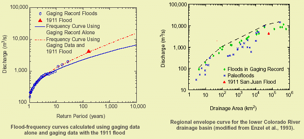
To calculate flood frequency, we combined the discharge of the 1911 flood with the pre-dam gaging data using an efficient method of moments procedure based on type II censoring (Cohn et al., 1997). The 1911 flood was considered as the largest between 1880 and 2001. Based on our analysis, the 1911 flood has an estimated recurrence interval of about 150 years. Including the 1911 flood in the frequency analysis increased the estimate of the 100-year flood by 44% from 2,240 m³/s (gaging data alone) to 3,210 m³/s (79,100 to 113,000 ft³/s respectively). To verify the reasonableness of the discharge of the 1911 flood, we plotted its value on the regional envelope curve for the Colorado River drainage (Enzel et al., 1993), with the result that the discharge plotted well below the enveloping curve.
The 1911 flood was not only the largest flood during the historic period, it is the largest flood that has left preserved evidence in the San Juan Canyon. No flood evidence was observed at elevations higher than the historic driftwood line deposited by the 1911 flood despite conditions ideal for the preservation of flood deposits. All flood deposits at elevations lower than the 1911 driftwood line contained evidence that indicated they were historic. This suggests that the 1911 flood may have been large enough to remove any flood deposits that were emplaced before 1911.
 |
